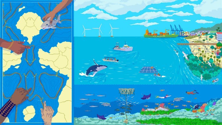
Marine Spatial Planning (MSP) has come to be globally acknowledged as a central mechanism for integrated and sustainable ocean governance. Conceptualised as an ecosystem-based and area-oriented planning framework, MSP seeks to coordinate the use of marine space across sectors—fisheries, shipping, tourism, offshore energy, conservation, and others—while safeguarding ecological resilience. As maritime activities accelerate and spatial pressures intensify, MSP provides governments with a structured approach to minimise inter-sectoral conflicts, optimise resource use, and guide long-term development in line with blue-economy objectives.[1]
The international trajectory of MSP reflects a decisive shift from fragmented, sector-specific regulation to comprehensive, spatially explicit planning. UNESCO’s Intergovernmental Oceanographic Commission (IOC) has articulated this shift through its 2025 global roadmap, calling for one-third of the world’s oceans to be brought under MSP processes. The fact that roughly 70 countries have already integrated MSP into national marine management frameworks underscores its growing policy relevance. Comparative global experiences also reveal a common pattern: MSP is most effective when anchored in strong legal mandates, supported by high-quality spatial data, and implemented through transparent, participatory and adaptive governance structures.
India’s evolving engagement with MSP reflects these broader global currents but remains at a relatively nascent stage. The Ministry of Earth Sciences (MoES) recognises MSP as being “essential” for unlocking the country’s blue-economy potential, particularly given the density of coastal populations, the expansion of maritime industries, and the rising vulnerability of coastal ecosystems.[2] Since 2021, the Government of India has initiated MSP pilot projects in Puducherry and Lakshadweep under the India–Norway Ocean Dialogue.[3] These pilot projects represent India’s first operationalisation of MSP, integrating coastal livelihoods, environmental sensitivities, hazard risks and sectoral priorities into spatial planning frameworks. However, the absence of a dedicated national MSP law, limited inter-agency coordination, and uneven data availability continue to pose challenges for scaling MSP beyond pilot settings.
Relevance of the Republic of Korea (RoK) Model
In this context, the RoK’s MSP experience provides valuable insights for India. The RoK model demonstrates how statutory backing, centralised coordination, and consistent stakeholder consultation can translate MSP from a conceptual tool into an enforceable governance instrument that balances development and conservation imperatives. Using Puducherry’s emerging MSP framework as a case study, this paper undertakes a comparative analysis to identify key lessons that India can draw from Korea’s experience. These include the need for legal codification of MSP, systematic data integration, stronger institutional linkages between central and state agencies, and mechanisms for continuous plan revision. Insights from Korea highlight pathways that could help India transition from experimental pilots to a coherent, nationwide marine spatial planning regime.
RoK’s MSP Act: Legal Foundations and Principles
South Korea formally institutionalised Marine Spatial Planning (MSP) through its “Act on Marine Spatial Planning and Management” (Act No 15607), promulgated on 17 April 2018.[4] The Act aims to “promote public welfare and establish a prosperous environment for the ocean” by providing a legal basis for the sustainable use, development and conservation of marine space.[5] It defines “marine space” broadly, covering inland waters, the territorial sea, the coastal zone, the EEZ, and the continental shelf, thereby creating a unified spatial governance framework across all maritime areas. Article 3 outlines the Act’s core principles, stating that the marine space must be managed comprehensively to balance ecological, cultural and economic values, while prioritising essential public needs such as national defence and navigation safety. The law also mandates public participation in MSP processes and encourages international and inter-Korean cooperation, underscoring South Korea’s commitment to integrated and collaborative ocean governance.[6]
The Act assigns explicit and differentiated responsibilities to central and local governments, requiring them to formulate policies that ensure the sustainable use, development, and conservation of marine space. These obligations create a coordinated governance structure that links national strategic priorities with local-level implementation. Importantly, it mandates information disclosure and public participation throughout the planning process. Governments are required under the law to release relevant data, invite comments, and engage stakeholders during plan formulation. This embeds transparency, accountability and social legitimacy into Korea’s MSP regime, reducing conflict and improving long-term compliance.
To operationalise these duties, the legislation establishes a two-tiered planning system. At the strategic level, the “National Master Plan on Marine Space” — prepared by the Ministry of Oceans and Fisheries (MOF) every ten years[7] — sets out the overarching vision for marine governance. It identifies policy priorities, spatial management objectives, sectoral coordination mechanisms, data and information systems, and research and development needs. This national plan provides the reference framework against which all subsequent spatial decisions must align. At the operational level, “Marine Spatial Management Plans” (MSMPs)[8] are developed for specific maritime areas. The MOF is legally mandated to prepare plans for the EEZ and continental shelf, while provincial and municipal governments draft MSMPs for the coastal waters under their jurisdiction. These local plans must be widely publicised and subjected to formal committee review and public hearings, ensuring that coastal communities, industries and civil society organisations can participate meaningfully in plan evaluation. This tiered and participatory structure enables the RoK to integrate national priorities with local contexts, leading to more coherent and adaptive marine spatial governance.
A central feature of Korea’s MSP legislation is the concept of the “marine use zone”[9], which reflects the law’s attempt to bring order and predictability to an increasingly congested maritime space. Article 2 defines a “marine use zone” as a designation intended “to reasonably distribute and manage” activities related to the use, development and conservation of marine areas. This framing is significant: it positions zoning not as an end in itself but as a regulatory tool for balancing competing uses, reducing user conflicts, and ensuring that marine development unfolds within ecologically acceptable limits.
Article 12 operationalises this concept by creating nine distinct Marine Use Zone categories[10], each representing a major domain of maritime activity (refer to Figure 1): (1) Fishery activity protection zones preserve traditional livelihoods and ensure food security; (2) Aggregate and mineral development zones regulate extractive industries; (3) Energy development zones support Korea’s offshore renewable energy agenda; (4) Marine tourism zones foster coastal recreation and cultural uses; (5) Environment and ecosystem management zones safeguard biodiversity and mitigate ecological degradation; (6)Research and education conservation zones protect sites vital for scientific monitoring; (7) Port and navigation zones secure the functioning of critical shipping corridors; (8) Military action zones address national defence requirements; and (9) Safety management zones support disaster preparedness and risk management.
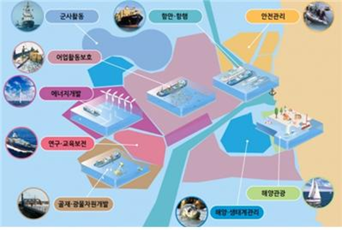 Fig 1: Nine Marine Use Zone as indicated in South Korea’s MSP Legislation
Source: Ministry of Ocean and Fisheries, Republic of Korea
Viewed analytically, the nine-zone system illustrates several core features of Korea’s MSP philosophy:
(a) Broad and integrated coverage. The categories span all major marine uses—fisheries, energy, tourism, conservation, navigation, defence and safety—ensuring no activity sits outside the planning framework. This reduces regulatory fragmentation and forces cross-sector coordination.
(b) Built-in balance between development and conservation. By placing extractive and energy zones alongside ecosystem management and research zones, the Act embeds a deliberate balance between economic growth and ecological protection.
(c) High regulatory clarity. Each zone is legally and functionally defined, giving authorities clear enforcement grounds and providing industries with predictability. This precision helps prevent overlapping claims—one of the most common causes of maritime conflict.
(d) Security and risk considerations. The inclusion of military and safety zones signals that marine governance must account for defence needs and hazard management, not only economic and environmental interests.
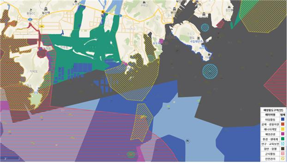 Fig 2: Marine Use Zones for Busan (Korea) as delineated in a February 2020 Marine Spatial Management Plan
Source: Ministry of Ocean and Fisheries, Republic of Korea
Under this zone-based regime, local plans specify which MUZ category applies to each sea area. For instance, the coastal waters of Busan have been divided into colour-coded zones for fisheries, tourism, ports, conservation, etc. as shown in Figure 2. This zoning is not arbitrary: designations were made only after an in-depth marine spatial assessment and public consultation, in line with the Act’s requirements. By assigning a primary purpose to every marine area, Korea’s system aims to minimise conflicts among industries (fishing, shipping, energy, tourism, etc.) while preserving critical habitats.
The Act also creates procedural checks. Articles 15–17 establish a Suitability Review for major marine development plans (e.g., building a port, offshore drilling, new tourism complexes, large aquaculture farms, etc.). These mandatorily need to be reviewed by the MOF to ensure consistency with the MSP zones[11]. The law specifies which projects trigger consultation and requires developers to submit spatial information in advance. In practice, the RoK has undertaken a rigorous review process – for example, the MOF reports that over 200 suitability reviews were completed in 2020 to vet projects against zoning plans.[12] This adds a layer of oversight so that sectoral approvals (by other ministries or local authorities) cannot override the spatial plan.
Importantly, the MSP system in the RoK is underpinned by data. Article 18 authorises the MOF to collect and integrate all relevant marine spatial data — from its own agencies, other public bodies, or even private firms — that is needed to formulate plans and evaluate characteristics. In line with this, Seoul has built an “Integrated Marine Spatial Information System”: a central GIS platform that aggregates bathymetry, marine habitat maps, port/fishery locations, shipping routes (AIS data), wind/energy surveys, and more.[13] High-resolution data feeds continuous analysis. Indeed, RoK is now developing advanced tools (AI and digital twin simulations) to test how different development scenarios might play out.[14] For example, a recent pilot in Sinan County (SW Korea) will use artificial intelligence to fuse traffic, environmental and economic data and simulate the impacts of various zoning options. These sophisticated, data-driven techniques ensure that RoK’s marine plans are grounded in science and can adapt to new information.[15]
India’s Blue Economy Strategy and MSP Initiatives
India does not yet possess a dedicated MSP statute. However, the government has explicitly acknowledged MSP as a foundational requirement for advancing a sustainable “blue” economy. The Draft National Policy for India’s Blue Economy (2021) identifies ecosystem-based MSP as a central mechanism for achieving maritime growth while minimising ecological degradation. Operationally, India has begun to pursue MSP through policy instruments and pilot-scale implementation. Under the 2019 Memorandum of Understanding with Norway—signed as part of the “Integrated Ocean Management and Research Initiative”—MSP was designated as one of the first areas of bilateral cooperation.[16] Following this, the Ministry of Earth Sciences (MoES) initiated the development of MSP frameworks and selected two pilot regions: the Union Territory of Puducherry on the east coast and the Lakshadweep island chain on the west coast.[17] These locations were chosen for their representative yet manageable spatial conditions. For example, Puducherry’s coastline hosts significant fishing and tourism activities, making it an ideal site for testing the integration of multiple marine uses within a structured spatial-planning regime.
Institutionally, India’s MSP pilots have been led by the National Centre for Coastal Research (NCCR) under the MoES, working in collaboration with international experts. The NCCR—together with the “National Centre for Sustainable Coastal Management” and Norway’s “Institute of Marine Research/Norwegian Environment Agency”—developed the draft MSP framework for Puducherry. The Union Territory’s government, through its “Department of Science & Technology” and local regulatory bodies such as the “Puducherry Coastal Zone Management Authority” (PCZMA), has been actively implementing the framework with inputs from local stakeholders.
The Indo-Norway partnership has played a critical technical role, drawing on Norway’s two decades of MSP experience to support India in navigating trade-offs among fisheries, offshore energy, shipping, and environmental protection.[18] A major milestone was achieved in February 2023, when the Government of Puducherry formally launched its first MSP framework alongside a shoreline-change atlas. During the inauguration, officials emphasised MSP as “a vital governance tool” for realising a blue economy that integrates sustainable ocean use with social equity.[19] Although India has not yet enacted a dedicated MSP law, its blue economy strategy and international collaborations have generated a strong policy commitment to ecosystem-based marine planning. The Puducherry and Lakshadweep pilot projects function as national testbeds, demonstrating how ocean data systems, GIS-enabled mapping, and participatory processes, can be combined to develop spatial plans aligned with national objectives. The Ministry of Earth Sciences has even articulated a seven-step MSP methodology—covering stakeholder engagement, visioning, data collection, spatial analysis, zoning, implementation and monitoring—tailored specifically to Indian conditions.[20]
Case Study: Puducherry’s Marine Spatial Plan
Puducherry’s MSP pilot illustrates how the ROK’s ideas might be applied in India. The “Puducherry Marine Spatial Plan” covers the nearshore Indian Ocean from the high-water line out to the limit of India’s Exclusive Economic Zone.[21] Its stated aim is to conserve critical marine ecosystems while accommodating human uses. Key habitats — extensive mangrove forests, coral reefs (notably around the outlying islets), and turtle nesting beaches — have been identified for protection. These areas are mapped in the plan as conservation/research zones. Concurrently, the plan maps zones for traditional fishing grounds and aquaculture, areas of high tourism potential, and navigation channels for shipping and ferries. For example, proposed cable corridors and exclusion zones are drawn to keep infrastructure away from reefs and safe shipping lanes. In effect, Puducherry’s plan creates a multi-layer zoning scheme: “fishing activity” zones, “aquaculture” zones, “coral reef conservation” zones, “tourism” zones, etc., each with regulations on permitted activities. This integrative zoning mirrors the RoK’s multi-use approach.
Stakeholder engagement has been central. Local fishermen’s cooperatives, tourism operators, conservation groups and other citizens were involved in defining the zoning priorities. Workshop reports indicate that community input shaped the location of sanctuary areas and guided trade-off decisions (for instance, setting aside some fisheries areas in return for alternate zones for tourism). The process is explicitly aligned with the UN SDG 14 (“Life Below Water”) goal of sustainable use. According to analysts, Puducherry’s MSP seeks to optimise fishing productivity (avoiding overfished areas) while ensuring new activities (like beach tourism) do not encroach on sensitive zones. In practice, this has led to maps that, for instance, protect mangroves and coral (critical for biodiversity and coastal protection) even as they allocate other nearshore areas for mariculture or offshore wind.
Technologically, the Puducherry plan uses a GIS-based decision-support system. A web portal called SAHAV[22] (a blend of Saagar and the Norwegian Hav, both denoting the sea/ocean) was developed to host all spatial data, model outputs and project proposals. Through SAHAV, planners can visualize layers (habitats, currents, human uses) and test “what-if” scenarios. The government has mandated that all new coastal projects (ports, marinas, energy projects, etc.) be fed into the system so that regulators can check compatibility with the MSP zones. The launch document notes that SAHAV provides real-time project tracking and supports adaptive approaches.[23] Indeed, SAHAV has been recognised by the “Digital Public Goods Alliance” as an open tool for transparent ocean governance.
The timeline of Puducherry’s MSP process further illustrates best practices. The initiative formally kicked-off in October 2022, with inception workshops (steps 1–2 in the framework). By February 2023 a spatial database was established via GIS (step 3), incorporating shoreline change maps and benthic surveys. Planning then proceeded to analysis and drafting of the zoning scheme. By late 2024, the first management plan (including mapped MUZs) was notified to authorities (steps 5–6). Throughout 2024–25, stakeholders continued to meet for iterative reviews, using the SAHAV dashboard to refine boundaries. Monitoring and enforcement mechanisms are being built in (step 7)[24] — for example, periodic meetings will update the plan based on new data (bathymetry surveys, sea-level studies) and track compliance of permitted uses. Overall, Puducherry’s case shows that India can operationalise MSP with a combination of law-like rigour and adaptive management — even if under an administrative regime rather than a statutory one.
MSP Approaches in Contrast: Korea’s Law and India’s Pilot Projects
The RoK and India exemplify two contrasting trajectories in the development of MSP. RoK’s regime demonstrates a mature, legally consolidated approach, where MSP functions as a core governance instrument rather than an advisory policy tool. The statutory framework mandates hierarchical planning cycles, codifies spatial categories and assigns non-negotiable governmental duties, creating a system that minimises jurisdictional ambiguity and aligns sectoral activities within a coherent national strategy. The legal definition of marine use zones further embeds spatial discipline into decision-making, enabling authorities to balance economic expansion with ecological limits and strategic priorities such as navigation safety and defence.
By comparison, India’s MSP landscape reflects a formative, experimental phase, shaped by policy directives, international technical assistance and pilot-based learning rather than binding legislation. This iterative model allows agencies such as NCCR to test methodologies, refine GIS-based planning tools and adapt approaches to local socio-ecological contexts. However, it also produces uneven institutional capacity, variable data quality, and limited regulatory enforceability. The Puducherry and Lakshadweep pilot projects operate primarily as methodological testbeds, enabling India to trial zonation concepts, stakeholder processes and spatial analyses before scaling to a national framework. Overall, while the RoK illustrates the outcomes of a fully institutionalised MSP architecture, India’s approach highlights the dynamics of institutional experimentation and capacity-building, marking an incremental but deliberate movement toward structured marine spatial governance. Table 1 depicts a detailed comparative analysis of MSP implementation undertaken by both the countries.
|
Table 1: Comparison: RoK’s MSP Act vs. India’s MSP Pilots
|
||
| Dimension | RoK: MSP Act (2018) | India: Emerging MSP Framework (Pilots) |
| Legal Basis | Dedicated, binding law: Act on Marine Spatial Planning and Management (2018) | No MSP law; guided by policy (Blue Economy Draft 2021) and bilateral cooperation |
| Definition of Marine Space | Broad statutory definition covering inland waters, territorial sea, EEZ, continental shelf, coastal zone | No legal definition; pilot areas defined administratively (Puducherry, Lakshadweep) |
| Objectives & Principles | Legally codified: sustainable use, ecological–economic balance, public welfare, transparency, national defence priority | Expressed in policy: sustainable blue economy, ecosystem-based planning; non-binding |
| Planning Structure | Two-tier statutory system: National Master Plan (10-year), plus Marine Spatial Management Plans (national & provincial) | Pilot-scale MSPs only; no national MSP plan or mandatory planning cycle |
| Zonation Framework | Nine legally defined marine use zones (fisheries, energy, tourism, ecosystem, navigation, military, etc.) | Zonation developed experimentally in pilots; no national classification |
| Data & Decision Tools | National marine data infrastructure mandated under law | GIS mapping, ecological surveys, stakeholder workshops developed ad hoc for pilots |
| Implementation Approach | Nationwide, legally enforceable MSP | Early-stage pilots serving as test cases for future scaling |
Source: Compiled by Author
Insights from Korea’s Marine Spatial Planning for India
India’s emerging MSP framework can draw several concrete and actionable lessons from the RoK’s experience, particularly in the areas of legal design, institutional coordination, zonation practices, data infrastructure, and adaptive governance. As India moves from pilot initiatives toward a more structured national approach, the RoK’s mature MSP system offers valuable insights into how coherent legislation, clear spatial categories and evidence-based planning can strengthen marine governance and support sustainable blue-economy development. The following recommendations for Indian policy-makers are believed to be germane:
- Strengthening the Legal and Institutional Architecture. India’s current MSP efforts operate without a dedicated statutory foundation, resulting in overlapping sectoral jurisdictions—across fisheries, ports, environment, energy, and coastal regulation. A comprehensive national MSP law would consolidate these mandates under a unified marine governance scheme. RoK’s statutory clarity—particularly the delineation of central and provincial responsibilities for different maritime zones—offers a useful reference point for India’s federal context, where coastal states and the Union government must coordinate seamlessly. Importantly, India would also benefit from embedding periodic statutory review cycles (e.g., every five years) to ensure marine plans remain responsive to emerging challenges such as climate-driven shoreline change, expanding blue-economy sectors, and evolving ecological baselines.
- Developing a Coherent Multi-Use Zonation Framework. India’s pilot projects already hint at an emerging spatial logic—fisheries grounds, tourism-use areas, coral protection zones and no-development stretches. To scale MSP nationally, India should formalise these into a multi-zone classification system, tailored to domestic ecological, socioeconomic and regulatory conditions. The RoK’s nine-zone typology demonstrates the value of a clear, legally backed scheme. That said, however, India must adapt zoning categories to its own priorities, such as artisanal fishing, coastal livelihoods, disaster-prone areas and high-biodiversity seascapes. Central to this effort is ensuring that zoning decisions are anchored in ecological evidence—overlaying data on mangroves, coral reefs, spawning grounds, migratory routes and endangered species habitats before finalising use-maps. This would prevent ad hoc allocations and operationalise India’s commitment to ecosystem-based planning.
- Building a National Marine Data Infrastructure. Robust data systems are essential for effective MSP. While India has made progress through initiatives such as the SAHAV dashboard and NCCR’s spatial databases, these remain fragmented and region-specific. India should work toward a nationally integrated marine data platform, drawing together shoreline-change assessments, seabed morphology, fisheries catch records, vessel traffic (AIS), pollution monitoring and socio-economic datasets. The RoK’s experience underscores the value of unified, interoperable data systems supported by continuous monitoring. Moreover, India could accelerate its transition to predictive, analytics-driven governance by incorporating scenario-modelling tools—such as AI-enabled impact simulations—to forecast how alternative zoning decisions may influence fish stocks, erosion patterns or habitat resilience. A science-based, transparent data regime would significantly enhance India’s capacity for anticipatory coastal decision-making.
- Institutionalising Stakeholder Participation. Sustained stakeholder-engagement is critical in a country where coastal communities depend heavily on marine resources. India’s pilot project in Puducherry demonstrates that participatory approaches build both legitimacy and compliance; local fishers, tourism operators, and NGOs, have all provided valuable inputs into spatial designations. For wider implementation, India should formalise participation requirements—either through a future MSP law or a national policy directive. Coastal states could establish Regional MSP Advisory Committees, ensuring structured representation from fishing collectives, industry, academia and civil society. Such institutionalisation would embed participatory governance into India’s marine planning culture rather than treating it as an optional consultative exercise.
- Embedding Adaptive and Iterative Planning. Marine conditions, socio-economic priorities and climate pressures evolve rapidly. MSP must therefore remain adaptable. The RoK’s legally mandated review cycles offer a useful procedural model but India should design an approach suited to its own environmental variability and governance needs. Puducherry’s evolving plan—updated with new habitat surveys and community feedback—already illustrates the benefits of iterative refinement. National MSP guidelines should, therefore, mandate regular plan revisions, allowing states and Union agencies to recalibrate zoning decisions in response to scientific updates, sectoral developments, or unforeseen coastal dynamics. Embedding adaptive management into India’s MSP system would ensure that marine spatial plans remain living documents rather than static regulatory artefacts.
Overall, Korea’s experience illustrates that an effective MSP regime combines strong legal backing, comprehensive zoning, rigorous data and broad participation. India’s current MSP pilots — exemplified by Puducherry — already incorporate many of these elements on a project level. The next step is to scale-up: adopting a national framework (preferably via the enactment of law), extending GIS platforms across all coasts, and building institutional capacity. In doing so, India can ensure that the rapid growth of its blue economy proceeds in harmony with ocean health — much as the RoK has aimed to do under its MSP system.
Conclusion
India stands at a formative but strategically significant moment in the evolution of its Marine Spatial Planning framework. The Puducherry and Lakshadweep pilot projects have demonstrated the feasibility of integrating ecological data, stakeholder perspectives and spatial analysis into a coherent planning process. However, these initiatives remain preliminary steps toward a fully institutionalised system of marine governance. The experience of the RoK underscores the advantages of legal clarity, structured zonation, and integrated data systems. Yet, India must adapt these insights to its own federal complexities, diverse coastal economies and rapidly changing ecological realities.
Moving forward, India’s MSP trajectory would benefit from establishing a robust statutory foundation, developing a nationally consistent yet locally adaptable zoning framework, and investing in a comprehensive marine data infrastructure that supports evidence-based decision-making. Equally important is the institutionalisation of participatory processes, ensuring that the voices of coastal communities, industry actors and civil society remain embedded within planning cycles. Finally, adopting an adaptive, regularly updated planning model will allow India to respond dynamically to climate impacts, emerging blue-economy sectors and evolving socio-ecological conditions. In sum, India’s MSP pathway is transitioning from experimentation to structured governance. With targeted legal, institutional, and data-driven reforms—guided but not constrained by international experience—India has the opportunity to craft a marine spatial planning system that is scientifically robust, socially inclusive and nationally coherent.
******
About the Author
Ms Arijita Sinha-Roy is a Research Associate at the National Maritime Foundation, New Delhi. Her research focuses on the manner in which the maritime geostrategies of India are impacted by those of East Asia in general and the Republic of Korea (RoK) in particular. She holds a Master’s degree in East Asian Studies, Department of East Asian Studies, University of Delhi. She is also an alumnus of the Yeosu Academy of the Law of the Sea (2024). Arijita can be reached out at irms4.nmf@gmail.com
Endnotes
[1] Republic of Korea, “Marine Spatial Planning”, Ministry of Ocean and Fisheries. https://www.mof.go.kr/page/en/selectPage.do?menuSeq=1576&pageSeq=1007&listUpdtDt=2025-11-28++10%3A00
[2] Government of India, “India’s Blue Economy: A Draft Policy Framework”, Economic Advisory Council to the Prime Minister, September 2020.https://services.incois.gov.in/documents/BlueEconomyPolicy-Draft.pdf#:~:text=(B)%20Coastal%20Marine%20Spatial%20Planning%20and%20Tourism.,recommendations%20on%20each%20which%20are%20discussed%20below.
[3] Government of India, National Centre for Coastal Research, Ministry of Earth Sciences. https://nccr.gov.in/?q=search/node/marine%20spatial%20planning
[4] Act on Marine Spatial Management, Statutes of the Republic of Korea, 2018. https://elaw.klri.re.kr/eng_mobile/viewer.do?hseq=51031&type=part&key=42
[5] Act on Marine Spatial Management, Statutes of the Republic of Korea, 2018. https://elaw.klri.re.kr/eng_mobile/viewer.do?hseq=51031&type=part&key=42
[6] Act on Marine Spatial Management, Statutes of the Republic of Korea, 2018. https://elaw.klri.re.kr/eng_mobile/viewer.do?hseq=51031&type=part&key=42
[7] Republic of Korea, “Marine Spatial Planning”, Ministry of Ocean and Fisheries. https://www.mof.go.kr/page/en/selectPage.do?menuSeq=1576&pageSeq=1007&listUpdtDt=2025-11-28++10%3A00
[8] Republic of Korea, “Marine Spatial Planning”, Ministry of Ocean and Fisheries. https://www.mof.go.kr/page/en/selectPage.do?menuSeq=1576&pageSeq=1007&listUpdtDt=2025-11-28++10%3A00
[9]The Korean Association of Ocean Science and Technology, “한국해양환경에너지학회”. https://kaosts.org/data/2024/%ED%95%9C%EA%B5%AD%ED%
95%B4%EC%96%91%ED%99%98%EA%B2%BD%EC%97%90%EB%84%88%EC%A7%80%ED%95%99%ED%9A%8C.pdf
[10] Hee Jung Choi, et al, “Assessment of Marine Use Zones (MUZs) in the Spatial Planning of Jeonbuk Sea Waters (Southwestern Korean Peninsula)”, Journal of Coastal Research, 116 (sp1), 338-342, 4 January 2024. https://doi.org/10.2112/JCR-SI116-069.1
[11] Act on Marine Spatial Management, Statutes of the Republic of Korea, 2018. https://elaw.klri.re.kr/eng_mobile/viewer.do?hseq=51031&type=part&key=42
[12] Act on Marine Spatial Management, Statutes of the Republic of Korea, 2018. https://elaw.klri.re.kr/eng_mobile/viewer.do?hseq=51031&type=part&key=42
[13]Jang Ahreum, “Korea’s Marine Spatial Management based on Ocean Data for a Sustainable Future”, UNSOD Workshop: From Lisbon to Nice: Implementing SDG 14 with the Communities of Ocean Action Review and Sharing of Best Practice and Lessons Learned on Access and Collection of Ocean Data, 14 September 2023. https://sdgs.un.org/sites/default/files/2023-12/Day1_Session2_Ms.%20Ahreum%20Jang.pdf
[14] Wenxi Zhu and Jinxia Zhao, “The Sub-Commission Designates Sinan County as a Marine Spatial Planning Demonstration Site in the Republic of Korea”, IOC Sub-Commission for the Western Pacific (WESTPAC), 23 August 2024. https://ioc-westpac.org/sinan-county-msp-demonstration-site/#:~:text=To%20address%20these%20challenges%2C%20the,Intelligence%20and%20Digital%20Twins%20technology
[15] Wenxi Zhu and Jinxia Zhao, “The Sub-Commission Designates Sinan County as a Marine Spatial Planning Demonstration Site in the Republic of Korea”.
[16] Government of India, Press Information Bureau, “Flash Flood Guidance Services launched; the first of its kind for South Asian countries namely India, Bangladesh, Bhutan, Nepal and Sri Lanka”, Ministry of Earth Sciences, 01 Jan 2021.https://www.pib.gov.in/Pressreleaseshare.aspx?PRID=1685411®=3&lang=2
[17]Government of India, “Launch of Marine Spatial Planning (MSP) for Puducherry and Lakshadweep as part of Indo-Norwegian Collaboration on Integrated Ocean Management”, Ministry of Earth Sciences. https://www.moes.gov.in/sites/default/files/Press-Release-MSP.docx_.pdf
[18] Government of India, Press Information Bureau, “India, Norway bilateral talks focus on powering Green Maritime Technologies”, Ministry of Ports, Shipping and Waterways, 04 June 2025. https://www.pib.gov.in/PressReleasePage.aspx?PRID=2133875®=3&lang=2
[19] Government of India, National Centre for Coastal Research, Ministry of Earth Sciences. https://www.nccr.gov.in/sites/default/files/th14feb23.pdf
[20] Ammavasai, M., Usha, T., Dash, S.K. et al. “Framework for Developing Marine Spatial Plans for Indian Regions: Towards a Resilient and Inclusive Blue Economy”, npj Ocean Sustainability, 01 November 2025. https://doi.org/10.1038/s44183-025-00160-3
[21] Ammavasai, M., Usha, T., Dash, S.K. et al. “Framework for Developing Marine Spatial Plans for Indian Regions: Towards a Resilient and Inclusive Blue Economy”.
[22] Ammavasai, M., Usha, T., Dash, S.K. et al. “Framework for Developing Marine Spatial Plans for Indian Regions: Towards a Resilient and Inclusive Blue Economy”.
[23] Ammavasai, M., Usha, T., Dash, S.K. et al. “Framework for Developing Marine Spatial Plans for Indian Regions: Towards a Resilient and Inclusive Blue Economy”.
[24] Ammavasai, M., Usha, T., Dash, S.K. et al. “Framework for Developing Marine Spatial Plans for Indian Regions: Towards a Resilient and Inclusive Blue Economy”.


Leave a Reply
Want to join the discussion?Feel free to contribute!