Rear Admiral Monty Khanna (Retd) – ‘Dabolim Diaries’ Issue No 20 dated 31 Mar 2026
The Guangzhou Marine Geological Survey (GMGS) operates under the direct control of China Geological Survey, Ministry of Land and Resources. It is a comprehensive scientific institution which conducts national basic, strategic and public beneficial investigation and research of marine geology. It started as the Marine Geological Scientific Research Institute of Geological Ministry which was founded on 24 December 1963 at Nanjing. It was renamed the Guangzhou Marine Geological Survey Bureau of the Ministry of Geology and Mineral Resources in 1989, and officially became the Guangzhou Marine Geological Survey in 2000. In 2022, it relocated entirely to Nansha District, Guangzhou, with its Deep-sea Science and Technology Innovation Center (Address: No. 1133 Haibin Road, Nansha District, Guangzhou, 511458).
The GMGS conducts geological prospecting in the fields of oil and gas resources, marine engineering geology, disaster geological survey, scientific survey of ocean geology, scientific survey of the South Pole, new energy investigation (gas hydrate) and marine high-technology. It has a staff of nearly 800 members of which 540 are researchers with different majors. Apart from the above responsibilities, the GMGS also plays a role in making a greater contribution to protecting China’s marine sovereign rights and exploring marine territorial resources.
Role
The main functions of the GMGS are as listed below: –
- Undertake marine geological surveys and associated scientific research
- Undertake exploration, trial production, and scientific research of marine natural gas hydrate resources
- Undertake prospecting of offshore petroleum and natural gas resources, mineral resources
- Undertake exploration of offshore strategic mineral resources, and related scientific research
- Undertake hydrogeological, engineering geological, environmental geological, and hazard geological surveys, comprehensive research, and monitoring work in offshore areas and coastal zones
- Undertake ocean geological and mineral resources investigation, development and utilization, experimental research, and polar geological scientific expeditions and research
- Undertake research on marine geological exploration methods and techniques, and research, development, and promotion of instruments and equipment
- Undertake marine geological survey data services, information product research and development, and geological data services; be responsible for the construction of the National Natural Gas Hydrate Database and the South China Sea Geological Database
- Conduct marine geological science and technology research, science popularization, and international cooperation
- Assist in the application of geological science and technology developments, and provide technical services and consultation
- Undertake other tasks assigned by the China Geological Survey
Facilities
The GMGS has five major bases covering a total area of 40 hectares. Details of each of these is given in the succeeding paragraphs.
- Deep-Sea Technology Innovation Center, Xingang Avenue, Nansha, Guangzhou (Fig 1). It serves as the headquarters base of the Guangzhou Marine Geological Survey. It houses major facilities such as the Natural Gas Hydrate Engineering Center, Deep-Sea Equipment R&D Center, and key laboratories for seabed mineral resources. It has a constructed area of approximately 150,000 square meters. It forms part of a broader marine science and innovation cluster in Nansha District, Guangzhou, which China is developing into a major ocean technology hub. Its focus areas include deep-sea robotics, marine resources, and offshore engineering. It is well integrated with waterfront facilities, research vessels, and industrial facilities supporting ocean exploration.
 Fig 1: Deep-Sea Technology Innovation Center
- Guangzhou Base, Dongfeng East Road, Yuexiu District, Guangzhou (Fig 2). The Guangzhou Base has a built-up area of approximately 25,000 square meters and is currently used as a support facility for marine geology, natural resource investigation, and related technical backup functions. It houses the marine geological production and scientific research management departments. It is well networked with other GMGS facilities.
 Fig 2: Guangzhou Base
- Sanya South China Sea Geological Technology Innovation Center, Yazhou Bay Science and Technology City, Sanya, Hainan (Fig 3). It covers an area of about 13.5 hectares and houses about 150,000 square meters of research facilities including labs and supporting infrastructure. The first phase of the project was completed and put into operation by the end of 2023 and houses Natural Gas Hydrate Engineering Center, Deep-Sea Equipment R&D Center, and key laboratories for seabed mineral resources. It serves as a major national-level research hub focused on advancing deep-sea exploration, technology, and resource development in the South China Sea. It was included in the national “Southern Initiative” key development plan in June 2022.
 Fig 3: Sanya South China Sea Geological Technology Innovation Center
- Dream Vessel Terminal, Longxue Island, Nansha, Guangzhou (Fig 4). It covers an area of 20 hectares, has a shoreline of 1,000 meters with a jetty of length 700 meters and depth 9 to 10 meters. It is capable of berthing five vessels including the 40,000-ton scientific drilling vessel Mengxiang. The associated onshore supporting buildings have a constructed area of approximately 12,000 square meters.
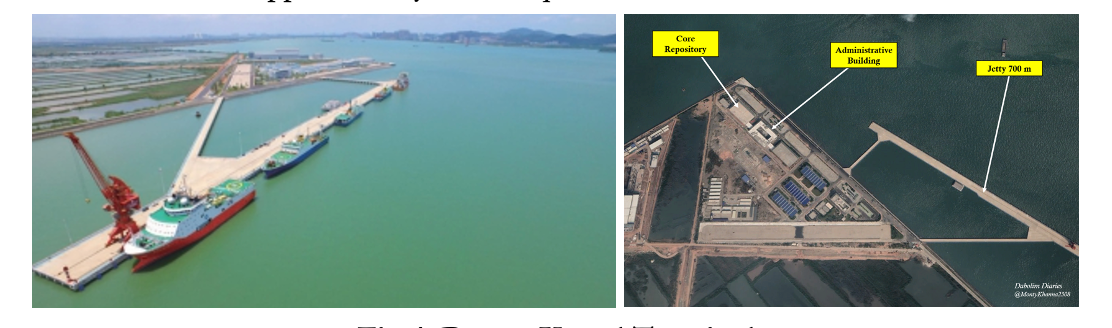 Fig 4: Dream Vessel Terminal
The terminal also hosts administrative facilities (Fig 5) and a world-class core repository, with a building area of approximately 16,000 square meters. It provides five temperature-controlled storage conditions; ambient temperature, +4°C, −20°C, −80°C, and −196°C. The repository has a core storage capacity of 900,000 meters and is equipped with a full life-cycle intelligent core management system. It supports several functions including core storage, analytical testing, scientific research and collaborative exchanges, and shared services.
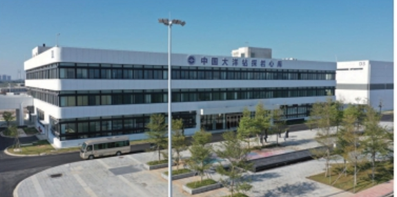 Fig 5: Administrative Building
- Marine Geological Terminal, Humen Town, Dongguan, Guandong (Fig 6). It has a jetty of length 250 meters and is capable of berthing two vessels of 5,000 tons each. Its supporting facilities cover an area of 4,493 square meters. With the construction of the new Dream Vessel terminal, the use of this berth is likely to decline.
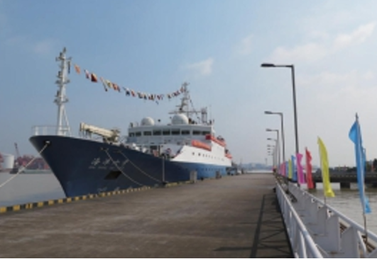 Fig 6: Marine Geological Terminal
Vessels
The GMGS operates several vessels, each of which carries the symbol of the China Geological Survey (CGS) on their funnel/ship side (Fig 7).
 Fig 7: Symbol of China Geological Survey
Details of the vessels are as given below.
- Meng Xiang (Dream) – Fig 8. The vessel is designed by the Marine Design and Research Institute of China, Shanghai and built by Huangpu Wenchong Shipbuilding Company, Guangzhou (part of the CSSC group). Construction commenced in November 2021 with delivery taking place on 17 November 2024. The vessel has a length of 179.8 meters, width of 32.8 meters, and displaces 42,600 metric tons. She has an endurance of 27,800 kilometers, and can sustain herself for 120 days without resupply. She has a maximum drilling depth of 11,000 meters. She typically sails with 180 sailors and researchers during scientific expeditions. She costs $412 million to build.
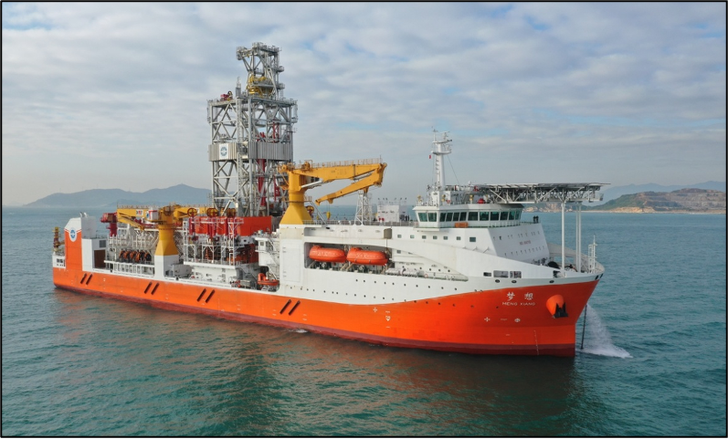
Fig 8: Meng Xiang (Dream)
- Haiyang Dizhi Ba Hao (Ocean Geology 8). She was built in 2017 and is equipped with an advanced high-resolution 3D seismic monitoring system. She has an endurance of 16,000 nautical miles and is used to conduct gas hydrate surveys.
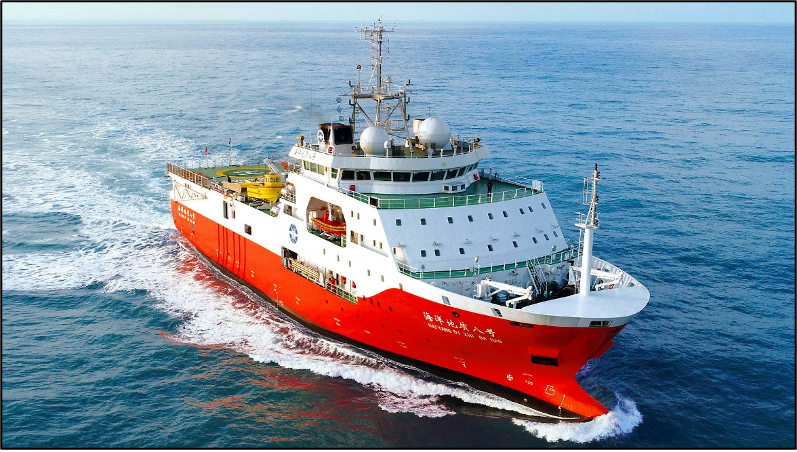 Fig 9: Haiyang Dizhi Ba Hao (Ocean Geology 8)
- Haiyang Dizhi Jiu Hao (Ocean Geology 9). A drilling-capable oceanographic survey vessel, she is able to drill 160 meters under the ocean bed 2,500 meters deep.
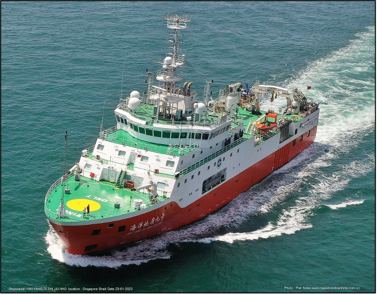 Fig 10: Haiyang Dizhi Jiu Hao (Ocean Geology 9)
- Haiyang Dizhi Shi Hao (Ocean Geology 10). She is a drilling-capable oceanographic survey vessel designed and built in China in 2017. She has a length of 75.8 meters, width of 15.4 meters, displacement of 3,400 tons and endurance of 8,000 nautical miles. In 2018/19, she carried out a joint expedition with Pakistani scientists in the Indian Ocean over 91 days.
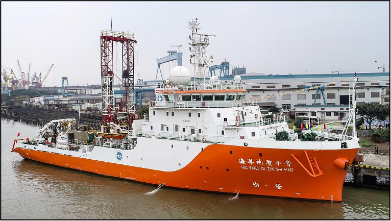 Fig 11: Haiyang Dizhi Shi Hao (Ocean Geology 10)
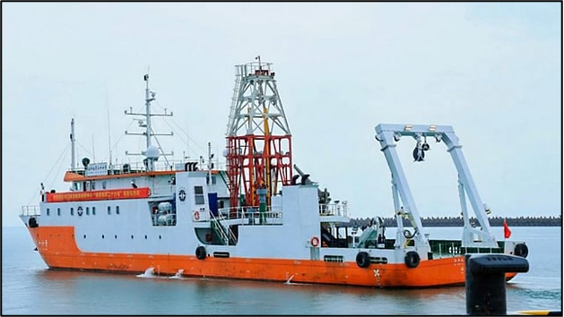
- Haiyang Dizhi Er Hao (Ocean Geology 2). She was built in 2020 as an Offshore Support Vessel. She is well equipped with cranes and winches and is designed to undertake heavy equipment handling. She works alongside other vessels such as the Mengxiang (Dream). She is fitted with facilities to operate ROVs in the 6000 m class.
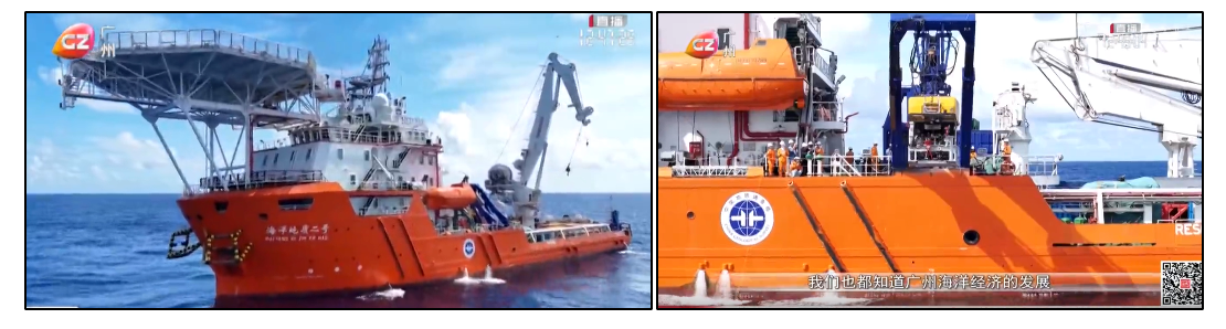 Fig 12: Haiyang Dizhi Er Hao (Ocean Geology 2)
- Haiyang Dizhi Shi Er Hao (Ocean Geology 12). Research Vessel built in 1978 and currently sailing under the flag of China. It is possible that this vessel, given its age, may have been taken out of service. A picture of the vessel is not available.
- Haiyang Dizhi 26 Hao (Ocean Geology 26). She was one of the first multi-functional scientific research vessels in China to be deployed for comprehensive geological survey and research involving reefs. She can embark 34 crew members and research personnel and has an endurance of 35 days. She is equipped with a dynamic positioning system (DP-1) and is fitted with single-beam and multi-beam echosounders, an acoustic current Doppler profiler, and equipment for collection of seismic data.
Fig 13: Haiyang Dizhi 26 Hao (Ocean Geology 26)
- Haiyang Dizhi Liu Hao (Ocean Geology 6 ). She was delivered in 2008. She is designed to carry out gas hydrate exploration and is capable of undertaking deep-sea ROV operations up to a depth of 4000 m for seabed sampling and hydrate recovery. She formerly went by the name Haiyang Liu Hao (Ocean 6).
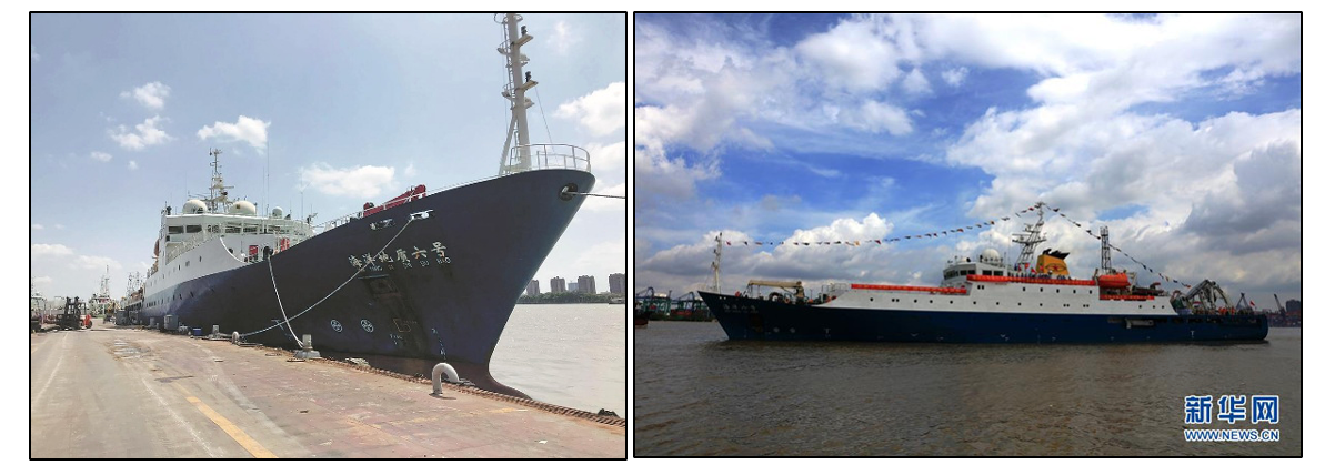 Fig 14: Haiyang Dizhi Liu Hao (Ocean Geology 6)
Table 1: Details of CGMS Research Vessels
| Name | Disp (Gross) | Length | Beam | IMO No | MMSI | Remarks | |
| Meng Xiang | 42600 | 180 | 33 | 9947108 | 414914000 | Deep sea drill ship | |
| HYDZ 2 | 4977 | 85 | 18 | 9793789
|
413243070 | Offshore support ship | |
| HYDZ 6 | 4335 | 106 | 17 | 9549126 | 412360000 | Oceanographic research ship | |
| HYDZ 8 | 6918 | 88 | 20 | 9780756 | 413491890 | 3D seismic monitoring ship | |
| HYDZ 9 | 5178 | 87 | 17 | 9780744 | 413331770 | Drilling capable research ship | |
| HYDZ 10 | 3400 | 76 | 15 | 9795751 | 413491880 | Drill ship | |
| HYDZ 12 | 2619 | 87 | 14 | 7714375 | 412461570 | Research vessel | |
| HYDZ 26 | 1713 | 63.5 | 13 | 413582210 | Multi-functional scientific research ship | ||
Assessment
The GMGS is a large organisation that has been engaged in the offshore prospecting of hydrocarbons for close to fifty years. Over this period, its capabilities have grown considerably. It has acquired a large fleet of vessels including the over 42,000-ton deep sea drilling ship Meng Xiang. It uses these to carry out offshore prospecting for hydrocarbons, not only in waters where China has sovereign rights but even beyond. These activities are sometimes undertaken at the invitation of littoral countries but this is not always the case. In 2023 for instance, the Haiyang Dizhi Ba Hao carried out an extensive survey lasting over a month, in the Luconia Shoals which lies within the continental shelf of Malaysia. During such deployments, GMGS vessels are often observed to go dark switching off their AIS transponders. On occasion, they are even escorted by vessels of the maritime militia or the China Coast Guard. A few of the GMGS vessels are equipped with ROVs which considerably expands their functionality allowing them to be used for tasks which go beyond their declared charter.


Leave a Reply
Want to join the discussion?Feel free to contribute!