 Photo-credit: Mr Tobias Friedrich at www.smithsonianmag.com
The United Nations Convention on the Law of the Sea (UNCLOS) 1982, entitles every coastal or island State to a varying degree of access and jurisdiction over its coastal seas. A belt of 12 nautical miles (nm) breadth, measured to seaward from the baseline (as delineated by the nation on its navigational charts and generally represented by the low-tide line along the coast, or as formally promulgated by it) corresponds to the “Territorial Sea” where the State enjoys full sovereignty and jurisdiction. Going farther seaward, a maritime zone, 24 nm in breadth, measured from the same baseline, is denoted as the “Contiguous Zone”. Here, the coastal State’s jurisdiction is limited to its fiscal, immigration, sanitary, and customs laws. An even broader zone, 200 nm in breadth, but once again measured from the same baseline, corresponds to the Exclusive Economic Zone (EEZ). Within the EEZ, the State has exclusive rights over all living and non-living marine resources, including those on the seabed and in the subsoil but enjoys no other sovereign rights or jurisdiction. Finally, if and where certain specific conditions prescribed by UNCLOS are demonstrably met, yet another belt, called the “Continental Shelf” (or the “Legal Continental Shelf”) might exist, whose breadth can extend even beyond the outer limits of the EEZ, to a maximum limit of 350 nm from the same baseline. Here, a coastal State enjoys exclusive rights over all living and non-living marine resources on the seabed and in the subsoil but not those in the water column between the seabed and the sea surface. If one were to compute the total area, including the “Legal Continental Shelf”, generated by the Indian peninsula and the country’s island territories, “maritime India” would be seen to encompass a sea area very nearly equal to the total land area of India. However, we have, thus far, only dipped our toes in the water, so-to-speak, when it comes to exploring, recording, and utilising this maritime space and the resources that lie within it.
While there are potentially limitless untapped resources in the EEZ that present significant opportunities for the expansion of India’s Blue Economy, the responsibility for the protection, conservation, and sustainable utilisation of these resources, particularly the living marine biodiversity, also falls upon Indian authorities. Part 1 of this two-part article series on “Decoding Marine Protected Areas (MPAs) in India” discussed in some detail the legal and policy frameworks in India, which govern the establishment of marine protected areas, and the difficulties in the long-term monitoring and effective management of MPAs. This second part of the series will highlight the rich biodiversity in India’s EEZ and why it must be protected by expanding the MPA coverage to regions in the EEZ which, at the moment, remain largely unprotected. The article will elaborate on the policy- and implementation challenges in establishing MPAs in the EEZ, largely due to their distant locations and lack of clear boundaries. It will also discuss the challenges that may arise in protecting a region of ecological significance, which happens to be shared by two or more countries, and the need for greater regional cooperation when it comes to conservation of shared areas by creating ‘transboundary’ MPAs.
Biological Diversity in Indian Waters
The “Ninth Conference of Parties” (COP 9) to the international “Convention on Biological Diversity” (CBD) adopted five criteria for the identification of suitable areas for establishing MPAs, of which one required the site to have been identified as an “Ecologically or Biologically Significant Area” (EBSA).[1]
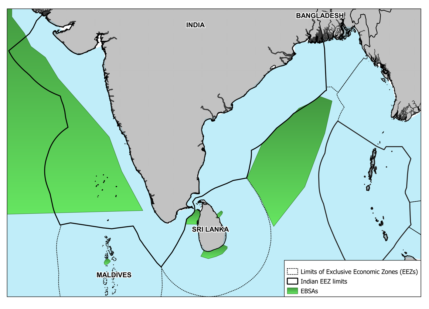
Figure 1: Ecologically or Biologically Significant Areas (EBSAs) in/ around India’s EEZ. Image created by author, Mr Eklavya Tiwary. Data Source: “Ecologically or Biologically Significant Marine Areas,” Convention on Biological Diversity, https://www.cbd.int/ebsa/ebsas and “Marine Gazetteer Placedetails,” Marineregions.org, https://marineregions.org/gazetteer.php?p=details&id=8480.
Indeed, as depicted in Figure 1, India’s EEZ overlaps several ecologically important and well-recognised EBSAs. These include the “Oxygen Minimum Zone” (OMZ) in the Arabian Sea, which contains a highly diversified ecosystem dominated by mesopelagic fish. In the Bay of Bengal, the EBSA for the Olive Ridley Turtle Corridor is positioned just outside the limits of India’s EEZ.
Several “Important Marine Mammal Areas” (IMMAs), as recognised by the “International Union for the Conservation of Nature” (IUCN) are also present across India’s continental shelf. These are areas of high ecological importance that could and should be delineated and managed for conservation. Figure 2 displays the various IMMAs in the region, with each of them symbolising the great amount of cetacean diversity in the region and the uniqueness of subpopulations endemic to the region, such as Arabian Sea Humpback whales. Additionally, other regions such as the floor of the Laccadive Sea, which harbours great micro-biodiversity in the several dozen seamounts it contains,[2] further highlight the biological significance of the EEZ.
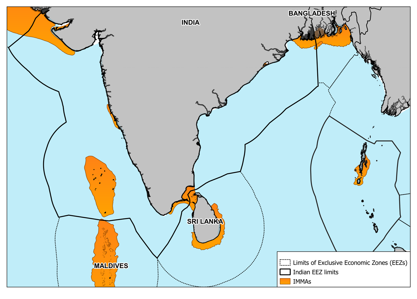
Figure 2: Important Marine Mammal Areas (IMMAs) in/ around India’s EEZ. Image created by author, Mr Eklavya Tiwary.
Data Source: IUCN MMPATF (2020) Global Dataset of Important Marine Mammal Areas (IUCN-IMMA). December 2020. Made available under agreement on terms and conditions of use by the IUCN Joint SSC/WCPA Marine Mammal Protected Areas Task Force and accessible via the IMMA e-Atlas http://www.marinemammalhabitat.org/imma-eatlas
The foregoing brief account highlights only a few of the areas of a profusely biodiverse, yet largely-unexplored and understudied, Indian EEZ. As is the case with much of the global ocean, these regions are facing fast-growing climate change threats that include rising ocean-temperatures, ocean acidification, and increasing extreme weather events such as prolonged marine heatwaves. In addition, the impacts of human overexploitation and marine pollution, the latter in the form of both, liquid effluents from industries and ships, and solid waste including plastic waste. Contemporary changes in the physical, chemical, and biological characteristics of the Indian Ocean are already leading to significant changes in the distribution and absolute populations of marine species and ecosystems.[3] These trends are expected to only get worse in the near- and long-term future. Therefore, there is an urgent need to develop mechanisms and establish practices to protect and conserve these areas of high ecological, socio-economic, and cultural relevance.
Marine Conservation in the EEZ
- Legal Frameworks
Spatial conservation tools such as Marine Protected Areas (MPAs), which have gained traction as the foremost method of conservation in the marine environment, have not yet been utilised for protecting the biodiversity in India’s EEZ. Thus far, no area beyond the Territorial Sea has been offered protection. As was discussed in Part I of this series, Protected Areas under the Wildlife Protection Act, 1972 are only applicable within the limits of the Territorial Sea. For conservation beyond these waters, the guiding provision lies within the Maritime Zones Act, 1976, which, inter alia, allows the Government of India (GoI) to demarcate any area in the Continental Shelf or within the EEZ for explorative, exploitative, and protective activities. The document acknowledges “protection of the marine environment” as one of the objectives that can permit the establishment of a “designated area.” [4] However, in the context of conservation, this provision had not been utilised, until recently when the submerged plateau of Angria Bank was proposed to be established as a ‘designated area’ by the state government of Maharashtra. Located 56.7 nautical miles off the Malvan coast, the plateau has gained a newfound recognition for its coral reef diversity, marine mammal habitats, and other marine flora and fauna. At the same time, this precise area is of considerable significance to the Indian Navy in terms of submarine and anti-submarine exercises. At the time of writing of this article, the state still awaits approval from the Centre on a final proposal that recommended 2,001.43 sq km to be protected under the provision of ‘designated area’ of the Maritime Zones Act, 1976.[5] The law allows the regulations and guidelines of the ‘designated area’ to be drafted on a case-to-case basis.
One of the main action points identified by the “National Wildlife Action Plan (NWAP) 2017-2031”, as was mentioned in Part I of this series, was to amend the Wildlife Protection Act, 1972 to incorporate MPAs within the EEZ.[6] The case of Angria Bank suggests that this step may not really be strictly necessary for establishing MPAs in the EEZ, since the Maritime Zones Act allows for ‘designated areas.’ This raises an important question, which of the two legal pathways should be pursued as the standard? The authors would argue that the ideal choice would be to amend the Wildlife Act and discard the use of the ‘designated area’ provision, due to the following reasons:
- The existing framework under the Wildlife Act, on the basis of which conservation plans such as those in the NWAP are built, provides for an already established and improving mechanism for the establishment, management, and monitoring of MPAs.
- The PA categories under the Wildlife Act are compatible with the recommended IUCN categories, with each category having different degrees of protection. Despite this, the PA coverage of India has been undermined in the IUCN’s World Database on Protected Areas. While the exact reason for this misrepresentation is unknown and requires remediation, such discrepancies often occur when countries establish PA networks that are not compliant with the IUCN guidelines. The ‘designated area’ provision offers no categorical classification and, as mentioned earlier, regulations would vary on an individual basis. This would create confusion and inconsistencies. A lack of systematic classification that is consistent with recommended standards would cause global databases to omit the particular MPA, thereby causing it to lose international recognition.
An amendment to the Wildlife Act would be most suitable to accommodate all aspects of MPA designation and management in the EEZ and it is suggested that the proposed Angria Bank ‘designated area’ should also be integrated into the same upon revision of the law.
- Recommendations for the Way Ahead
The NWAP (2017-2031) also pointed out the need to identify potential areas for the establishment of MPAs in the EEZ and extended the responsibility to a number of government and academic institutions, including the Ministry of Environment, Forests and Climate Change (MoEFCC), State Forest Departments, State Fisheries Departments, the Indian Coast Guard, the Indian Navy, the Centre for Marine Living Resources and Ecology (CMLRE), the National Institute of Oceanography (NIO), the National Centre for Polar and Ocean Research (NCPOR), the National Institute of Ocean Technology (NIOT), the Central Marine Fisheries Research Institute (CMFRI), the Fishery Survey of India (FSI), the Zoological Survey of India (ZSI), and, the Wildlife Institute of India (WII).[7] Work on this score began in 2017 and is expected to continue throughout the period of the action plan. Considering this growing interest in establishing MPAs in the EEZ, along with more ambitious global biodiversity conservation targets, this sub-section provides some suggestions for a way forward based on lessons learnt from global best-practices.
- Spatial conservation in the EEZ of nations is often done through the creation of “Large-scale Marine Protected Areas” (LMPAs), i.e., MPAs exceeding 1,00,000 sq km in area. There has been an increase in LMPAs, globally, since the turn of the century, going from a total of 5 in the year 2000 to 33 in 2019.[8] Although, their effectiveness has been hotly debated, with critics highlighting the difficulties in managing such large areas, the high costs for relatively low socio-ecological benefits, and, more significantly, the assertion that LMPAs can be used as a convenient tool to show greater ‘protected area’ coverage to fulfil area-based conservation targets.[9] Be that as it may, with careful site selection and well-thought-out management strategies, many scientists and conservationists believe that the benefits of LMPAs would outweigh the costs. One of the more significant gains is through large ‘biomass spill-over’ to regions outside the boundaries of the LMPA. Fish-stock replenishment ‘within’ as well as ‘outside’ the LMPA can be ensured, so long as the LMPA strategically covers critical habitats and biodiversity hotspots[10]
- Deep-sea fish beyond 200m depths of the Indian EEZ have an estimated standing stock of 3.81 million tonnes.[11] The country has been planning to expand its domestic infrastructural capacity and operational capabilities in deep-sea fishing in the EEZ. In 2017, India withdrew permission for foreign deep-sea fishers in the EEZ[12] and initiated a three-year pilot project that seeks to replace trawlers in the Palk Bay with 2,000 deep-sea vessels in the Bay of Bengal.[13] Considering the adverse impacts of climate change and other human activities on fisheries production on the one hand, and the growing demand for food production on the other, it is obvious that there would be an increased emphasis towards utilising the under-exploited fish stocks in the EEZ in the near future. In this context, the establishment of appropriately positioned LMPAs, which provide better fisheries-returns along with complementary high-value ecosystem services, becomes even more important.
- Interestingly, for large mobile species such as tuna, sharks, and even turtles, research suggests that establishing a network of smaller MPAs along migratory corridors and breeding (spawning) grounds proves more beneficial than the LMPA approach.[14] Four species of tuna are available in the deeper regions of the Indian EEZ, namely, the yellowfin tuna, the skipjack tuna, the dogtooth tuna, and the bigeye tuna.[15] The rapid decline of yellowfin tuna catch in the Indian Ocean, due to overfishing, is said to have had knock-on effects on the more commonly available skipjack tuna.[16] In order to realise the full potential of Indian fisheries, domestic deep sea tuna longlining is being actively promoted and pursued in the EEZ.[17] Fostering strategically formulated and well-managed MPA networks could prove beneficial in restoring stock and ensuring sustained extraction for the country. Migratory networks of MPAs could also be applied for many of the other large cetacean species that pass through Indian waters. When it comes to migratory species that routinely cross state or national boundaries, overexploitation in any one of the regions in their paths can lead to an overall decline of stock (as has been the case with yellowfin tuna across the Indian Ocean). This, therefore, demands greater cooperation between and consistent efforts by Indian Ocean littoral and island States to protect and preserve the common marine biodiversity so that all States can reap the socio-economic and ecological benefits. As such, this has foreign-policy implications for regional cooperation, particularly (but certainly not limited to) cooperative sub-regional multilateral structures such as BIMSTEC and the India-Maldives-Sri Lanka trilateral. Such cooperative approaches would provide much-needed substance to India’s frequently-articulated vision of SAGAR. In short, it is high time that the Ministry of External Affairs (MEA) is brought firmly into the regional maritime conservation/food-security loop.
Challenges and Opportunities in Transboundary Conservation
As indicated above, marine species do not understand the concept of international boundaries. For them, there is only one global ocean. It is often the case that ecologically significant regions and species transcend maritime boundaries, where all the countries involved must play their part in protecting and conserving the region. The IUCN recognises three forms of transboundary conservation: (a) Transboundary Protected Areas; (b) Transboundary Conservation Landscapes and/or Seascapes; and (c) Transboundary Migration Conservation Areas. Additionally, each of the above can be given the status of a “Peace Park” to promote/ celebrate/ commemorate peace between countries.[18] In the marine environment, too, transboundary conservation takes shape in one of the above forms. Table 1 displays the key features of each category.
| Table 1:
Comparison of Key Characteristics of Types of Transboundary Conservation Areas |
|||
| Characteristic | Transboundary Protected Area | Transboundary Conservation Landscape/ Seascape | Transboundary Migration Conservation Area |
| Cooperation across international boundary | Yes | Yes | Yes |
| Contains protected areas | Yes | Yes | Not necessarily |
| Contains areas that are not protected but, are sustainably managed | No | Yes | Not necessarily |
| Shared ecosystem(s) | Yes | Yes | Not necessarily |
| Relative physical proximity between units within a TBCA | Yes | Yes | Not necessarily |
| Transboundary cooperation in species/ habitat management | Yes | Yes | Yes |
| Protection of migratory species is the key mission for cooperation | Not necessarily | Not necessarily | Yes |
| Transboundary cooperation in the day-to-day management, strengthening of local community relations, visitor management, security considerations | Yes | Yes | Not necessarily |
| Source: Maja Vasilijevic et al, Transboundary Conservation: a Systematic and Integrated Approach (Gland: IUCN, 2015) https://doi.org/10.2305/IUCN.CH.2015.PAG.23.en | |||
Maintaining ecological connectivity to build greater integrity amongst common ecosystems (especially in the face of accelerating climate change) is the primary argument for undertaking transboundary conservation. Such cooperative conservation is especially essential in the marine environment since its inherently fluid nature does not give heed to arbitrary international boundaries. This is being increasing acknowledged by the international community. A few prominent examples of transboundary conservation efforts include the “Pelagos Sanctuary for Cetaceans in the Mediterranean”, involving cooperation amongst France, Italy, and Monaco; the “Wadden Sea MPA Network” governed by Germany, Netherlands, and Denmark; the “Ombai Strait Transboundary Corridor” between Indonesia and Timor Leste, and, the “Red Sea Marine Peace Park” between Jordan and Israel.
However, as outlined by the IUCN and shown in Table 2, the extent and nature of cooperation between countries engaging in transboundary conservation could vary quite a lot depending on the specific model being used. These models of cooperation may overlap and be adopted simultaneously. The selection of the specific model is situation-dependent and should be chosen according to the needs, interests, and political and socio-economic circumstances of the conservation area and the countries involved.[19]
| Table 2: Models of Cooperation in Transboundary Conservation | |
| Model of Cooperation | Example |
| Communication- or Information Sharing | Regular communication on actions, problems, opportunities or other relevant issues Regular sharing of information; e.g., notifying one another about various management actions in a particular site |
| Consultation | Seeking opinions, feedback or advice from one another; for instance, on how to solve a problem, how to improve a management action, etc. Cooperative processes aimed at harmonising management |
| Coordinated Action | Jointly coordinated management actions implemented within the sovereign areas of each party, which contribute to the conservation goals of the entire transboundary ecosystem; e.g., the monitoring of species and ecological processes occurs as regular activity on the territory of each party, but the shared results contribute to conservation of species or ecosystems in the whole shared ecosystem This model is considered to be a form of cooperative management |
| Joint Implementation of Decisions | Jointly coordinated and implemented management actions across the sovereign boundaries; e.g., joint law-enforcement patrols, joint fundraising and project implementation, the production of marketing material that profiles the TBCA as a single entity, etc. This model is considered to be a form of cooperative management |
| Source: Maja Vasilijevic et al, Transboundary Conservation: a Systematic and Integrated Approach (Gland: IUCN, 2015) https://doi.org/10.2305/IUCN.CH.2015.PAG.23.en | |
India shares its International Maritime Boundary Line (IMBL) notionally with Pakistan, and via international agreement with Maldives, Sri Lanka, Bangladesh, and Myanmar. It also shares a mutually agreed EEZ boundary with Thailand, and a Continental Shelf boundary with Indonesia. Yet, as things presently stand, there is no form of marine transboundary conservation in place across these boundaries. As discussed earlier, in India, a rigorous legal framework for MPA designation beyond the Territorial Sea is yet to be formally adopted, but, it is being formulated as part of the NWAP (2017-2031). Assuming that appropriate amendments will, indeed, soon be adopted, this section briefly analyses the potential to establish transboundary MPAs with Bangladesh and Sri Lanka as a mechanism to operationalise the commitments made by these nations and India to tackle marine environmental and fisheries issues under initiatives such as the “Bay of Bengal Large Marine Ecosystems” (BOBLME) Project.[20]
Potential for Transboundary Conservation with Bangladesh
India’s international boundary with Bangladesh slices through the Sundarbans. The deltaic coastline of Bangladesh is home to an array of mangroves that provide critical habitats for numerous terrestrial and aquatic species. In its coastal and marine waters, Bangladesh possesses 475 bony, and 50 cartilaginous fish species, 185 crustacean species, 50 crab species, 36 species of shrimp, among others.[21] An expansive IMMA is also mapped across the maritime boundary with India, and oceanographic conditions here are known to support some of the threatened cetacean species better than other coastal areas in the Indo-Pacific.[22] Many of the pelagic as well as demersal species are also known to move across long distances, oblivious of the maritime boundary. Although, progress has been made in identifying the size and movement of important hilsa and mackerel stocks in the larger portion of the Bay,[23] further assessments are required to trace fish stocks between the EEZs of the two countries.[24]
Notably, Bangladesh has established several coastal MPAs, conserving its many mangrove and estuarine ecosystems over the years. It declared its first offshore MPA, the Swatch-of-No-Ground MPA – a submarine canyon marked as an IMMA, in 2014. Marine conservation has gained much traction in the country, with consistently increasing MPA establishments and plans to improve marine and fisheries legislations to account for environmental protection.[25] However, conservation efforts are being threatened by stressors from upstream land-based waste discharges as well as overexploitation and IUU fishing. Hilsa sanctuaries in Bangladesh have a seasonal 65-day ban to restore fish stocks. However, some studies suggest that as many as 60 per cent of fishers ignore the ban and that more than 90 per cent use illegal gear within the sanctuaries.[26] Indian fishers have also been known to cross over in search for catch during the ban period. As a consequence, social inequity pervades between fishers who comply with the bans and those who do not. Ban periods in the hilsa sanctuaries place serious strains on the livelihood of compliant fishers and the current compensation scheme is believed to be insufficient, non-inclusive, and poorly administered.[27]
Marine transboundary conservation between India and Bangladesh would go a long way to replenish fish stocks through biomass spillover and further assist in holistic biodiversity conservation. The IUCN also urges cooperation between the two neighbours in order to conduct detailed assessments on resident and migratory species and develop subsequent cooperative MPA networks.[28] A 2019 study identified potential sites in the Bangladesh EEZ for MPA declaration.[29] Although, none of these delineations cross the IMBL with India, as per the IUCN guidelines, transboundary conservation can occur between PAs located between two countries that might be separated by non-protected areas and does not necessitate contiguity across international borders.
However, if such efforts are to be undertaken, they would require conflict resolution, rigorous enforcement, and compliance mechanisms. It is necessary to inculcate responsible attitudes towards conservation amongst the non-compliant fisher groups. In this context, integrating effective community-level management along with top-down management models are essential for the long-term success and sustenance of shared MPAs.
Potential for Transboundary Conservation with Sri Lanka
The IMBL with Sri Lanka is situated across the Gulf of Mannar and Palk Bay between the south-eastern tip of the Indian subcontinent and the north-western coast of Sri Lanka. The region is famous for its biodiversity, with 130 species of corals, 17 species of mangroves, 147 species of seaweeds, 79 species of crustaceans, 108 species of sponges, 260 species of molluscs, and 1182 fish species.[30] The shallow waters of the Gulf possess seagrass, seaweed, corals, and mudflats. These, along with the coastal estuaries and lagoons, serve as breeding grounds for many fish species.[31] Additionally, the Gulf also hosts migratory whales, dolphins, and four of the seven existing species of sea turtles, and, is also home to the endangered Dugong.
On the Indian side, conservation is carried out through the “Gulf of Mannar Marine National Park”, established in 1986, and covering 21 islands and their adjacent coral reefs off the coast between Tuticorin and Dhanushkodi, with a total area of 560 sq km. The National Park forms a core area to the larger “Gulf of Mannar Biosphere Reserve”, established in 1989 under the UNESCO Man and Biodiversity programme, covering an area of 10,500 sq km. Across the Gulf, Sri Lanka has established the “Bar Reef Sanctuary” making it the country’s largest MPA covering approximately 310 sq km. Coastal MPAs such as “Vankalai Sanctuary” and the “Adam’s Bridge Marine National Park” have also been established under the “Flora and Fauna Ordinance”.
Maritime governance in the Gulf of Mannar and Palk Bay has had its own set of historical challenges. IUU fishing is a common occurrence, with Indian trawler fishers often crossing the IMBL in search of catch, quoting “traditional rights” as justification. The disputed Katchatheevu Island, which is Sri Lankan territory but to which the people of Tamil Nadu assert their claim, has also been at the centre of confrontational politics. Fishers in mechanised craft seasonally migrate from different regions in Tamil Nadu to find catch and are encouraged by state-level politicians.[32]
Bilateral engagements between the two countries have constantly attempted to resolve this complex issue. Artisanal fishers arrested by Sri Lanka are often released based on a mutual understanding with India, taking into account the humanitarian aspect of the problem. However, Sri Lanka has usually been somewhat more reluctant to release mechanised vessels, as there is a genuine fear of destruction of fisheries on their side. More recently, at the fourth meeting of the “India-Sri Lanka Joint Working Group on Fisheries”, the Indian representation reiterated the need to release the boats in their custody, as per a commitment made by the Sri Lankan President.
The development of deep-sea fishing boats to replace mechanised trawlers in the Palk Bay has been repeatedly suggested as a solution and efforts in this direction have begun, albeit at a slow pace.[33] This transition is expected to take time as it requires adequate capacity-building (suitably equipped vessels, cold storage, on-board canning facilities, etc.) as well as capability-enhancement (fisherfolk training).[34] However, these advancements will not restore the heavily overfished and severely depleted fish stocks at the Indian side, upon which millions of artisanal fisherfolk are reliant for their daily sustenance.[35] Local communities are rarely involved in the decision-making process related to new fisheries development policies and projects. Admittedly, some projects, such as those implemented by the “Gulf of Mannar Biosphere Reserve Trust”, have attempted to incorporate livelihood development programs, albeit with limited success.[36]
Joint governance and management between the two countries in the region has been proposed as the most suitable long-term solution to resolve the fishing problem.[37] The same is true for conservation as they share a single highly productive ecosystem that is ecologically connected with cross movement of many species. The existing MPAs off each coast form a fragmented approach to protection. Moreover, the area under the “Gulf of Mannar Biosphere Reserve” does not enjoy adequate protection and is merely seen as a buffer zone to the “Gulf of Mannar Marine National Park”. Along with biodiversity conservation, the larger challenge is to rejuvenate fish stocks in these waters, which could be achieved through the creation of a Transboundary MPA that would potentially lead to high biomass spillover across boundaries. As trawler fishers make the switch to deep sea fishing, it would provide time for the fish stocks to recover and for the benefits of spillover to accrue. Moreover, fisher populations on both sides (who are tied by shared Tamil ethnicity) could be integrated to create community-level management and monitoring mechanisms. Some of these groups have already been assisting the Forest Department in tracking illegal activities, poaching, and narcotics trafficking around the “Gulf of Mannar Marine National Park”. However, there is still a large trust-deficit between local fishers and authorities, on both, the Indian and the Lankan sides.[38] Efforts for MPA creation in Sri Lanka also show difficulties in gaining community support, as the communities fear that they will lose their livelihoods if fishing restrictions are enforced.[39] Thus, it becomes all the more critical to better educate the local communities about the benefits of MPAs. The long-term success of the conservation efforts will undoubtedly depend on effective community-engagement and the degree to which they can be meaningfully involved in the various management processes.
********************
About the Authors:
* Mr Eklavya Tiwary, at the time of writing this article, was an intern in the WINTER 2020-21 (Extended) internship programme at the NMF. He may be contacted at eklavya.tiwary1@gmail.com.
** Dr Pushp Bajaj is a Research Fellow and the Head of the Blue Economy and Climate Change Cluster at the NMF. His current research focuses upon the impacts of climate change on India’s holistic maritime and naval security. He may be contacted at climatechange2.nmf@gmail.com.
Endnotes:
[1] Youna Lyons and Denise Cheong, “The International Legal Framework for the Protection and the Sustainable Use of Biodiversity” in Routledge Handbook of Biodiversity and the Law, eds Charles R McManus and Burton Ong, (Routledge, 2017).
[2] Identifying Conservation Needs in India’s Offshore Waters, Greenpeace India Society, (Bangalore, 2014).
[3] Pushp Bajaj and Akshay Honmane, “Climate Risks to India’s Holistic Maritime Security- Part 3: Collapsing Ocean Biodiversity,” National Maritime Foundation Website, 04 November 2020, https://maritimeindia.org/climate-risks-to-indias-holistic-maritime-security-part-3-collapsing-ocean-biodiversity/.
Also see: Sarita Fernandes and Pushp Bajaj, “Implications for India of Noctiluca Scintillans in the Maritime Domain,” National Maritime Foundation Website, 06 May 2021, https://maritimeindia.org/implications-for-india-of-noctiluca-scintillans-in-the-maritime-domain/.
[4] Maritime Zones Act (1976), The Gazette of India, https://legislative.gov.in/sites/default/files/A1976-80_0.pdf
[5] Badri Chatterjee, “India inches towards first marine ‘designated area’ off Maharashtra coast,” Hindustan Times, 29 November 2020, https://www.hindustantimes.com/mumbai-news/india-inches-towards-first-marine-designated-area-off-maharashtra-coast/story-P8RPgVUfug8tqtLq9spl1I.html
[6] National Wildlife Action Plan (2017-2031), Ministry of Environment, Forest and Climate Change (MoEFCC), https://wii.gov.in/nwap_2017_31.
[7] Ibid
[8] Chris Smyth and Quentin Hanich, Large Scale Marine Protected Areas: Current Status and Consideration of Socio-Economic Dimensions (Australia: Australian National Centre for Ocean Resources and Security, University of Wollongong, 2019), https://www.pewtrusts.org/-/media/assets/2019/03/mpa-research-agenda-for-public-release-final.pdf
[9] Bethan C O’Leary et al, “Addressing Criticisms of Large-Scale Marine Protected Areas”, BioScience 68, No 5 (2018): 359–370. https://doi.org/10.1093/biosci/biy021
[10] Smyth and Hanich, Supra Note 8
[11] V N Sanjeevan, “Deep-Sea Fishery Resources of the Indian Exclusive Economic Zone,” Geography and You, 27 September 2018, https://geographyandyou.com/deep-sea-fishery-resources-of-the-indian-exclusive-economic-zone-eez/
[12] Shaju Philip, “Explained: Why is Kerala Govt Caught in a net Over a Deep Sea Fishing Deal,” The Indian Express, 24 February 2021,
[13] Ajit Menon and Johny Stephen, “Is Deep Sea Fishing the Silver Bullet?” The Hindu, 11 October 2017, https://www.thehindu.com/opinion/op-ed/is-deep-sea-fishing-the-silver-bullet/article19834939.ece
[14] Smyth and Hanich, Supra Note 8
[15] E M Abdussamad et al, “Indian Tuna Fishery – Production Years During Yesteryears and Scope for the Future,” Indian Journal of Fisheries 59, No 3 (2012): 1-13.
[16] Katy Askew, “Yellowfin Tuna ‘heading for collapse’ by 2026: A 20% Reduction in Catch Would Turn the Tide,” FoodNavigator.com, 18 March 2021, https://www.foodnavigator.com/Article/2021/03/18/Yellowfin-tuna-heading-for-collapse-by-2026-A-20-reduction-in-catch-would-turn-the-tide.
[17] “Four Tuna Longliner Vessels Expected Soon,” The Hindu, 13 May 2019, https://www.thehindu.com/news/national/tamil-nadu/four-tuna-longliner-vessels-expected-soon-first-batch-built-by-the-cochin-shipyard-limited-was-released-in-february/article27111137.ece
[18] Maja Vasilijevic et al, Transboundary Conservation: a Systematic and Integrated Approach (Gland: IUCN, 2015) https://doi.org/10.2305/IUCN.CH.2015.PAG.23.en
[19] Ibid
Also see: Christopher Costello and Renato Molina, “Transboundary Marine Protected Areas,” Resource and Energy Economics 65 (August 2021), https://doi.org/10.1016/j.reseneeco.2021.101239
[20] The Bay of Bengal Large Marine Ecosystem Project, https://www.boblme.org/.
[21] Subrata Sarker et al, “Zoning of Marine Protected Areas for Biodiversity Conservation in Bangladesh,” Ocean and Coastal Management 173, (May 2019):114-122, https://doi.org/10.1016/j.ocecoaman.2019.03.002.
[22]“Coastal Northern Bay of Bengal IMMA,” Marine Mammal Protected Areas Task Force, https://www.marinemammalhabitat.org/portfolio-item/coastal-northern-bay-bengal/.
[23] Joydeep Gupta, “Eight Countries Come Together to Protect Bay of Bengal,” Down to Earth, 4 July 2018, https://www.downtoearth.org.in/news/environment/eight-countries-come-together-to-protect-bay-of-bengal-61018
[24] Mohammad Arju, “Lines on Water Cannot Save Bay of Bengal Fisheries,” The Third Pole, 15 May 2020, https://www.thethirdpole.net/en/regional-cooperation/going-beyond-bay-of-bengal/
[25] M Mahmudul Islam, “Social Dimension in Designing and Managing Marine Protected Areas in Bangladesh,” Human Ecology 49, No 2 (2021):171-185, https://doi.org/10.1007/s10745-021-00218-z.
[26] Ibid
[27] Ibid
[28] Framework for the Establishment and Management of Marine Protected Areas in Bangladesh, (Dhaka: IUCN, 2014), https://www.boblme.org/documentRepository/BOBLME-2015-Book-02.pdf
[29] Sarker et al, Supra Note 21
[30]M A Aathichoodi, “Conservation and Sustainable Use of Gulf of Mannar Biosphere Reserve,” International Journal of Science and Research 8, No 12 (December 2019), https://www.ijsr.net/archive/v8i12/ART20203564.pdf
Also see: Ramya Rajagopalan, Marine Protected Areas in India (Chennai: International Collective in Support of Fishworkers, 2008)
[31] K K Joshi et al, “Checklist of Fish of the Gulf of Mannar Ecosystem – Tamil Nadu – India,” Journal of the Marine Biological Association of India 58, No 1 (July 2016), 34-54.
[32] R S Vasan, “Illegal, Unreported and Unregulated (IUU) Fishing in Palk Bay,” National Maritime Foundation Website, 20 February 2017, https://maritimeindia.org/illegal-unreported-and-unregulatediuu-fishing-in-palk-bay-issues-and-challenges/
[33] T Ramakrishnan, “Deep Sea Fishing Scheme Makes Slow Progress,” The Hindu, 19 December 2020, https://www.thehindu.com/news/national/tamil-nadu/deep-sea-fishing-scheme-makes-slow-progress/article33369040.ece
[34] Vasan, Supra Note 32
[35] Rahul Muralidharan, “Open Letter: Why is Tamil Nadu neglecting Its Artisanal Fishers,” The Wire, 30 July 2017, https://thewire.in/environment/artisanal-fishers-tamil-nadu-sri-lanka-trawling
[36] Rahul Muralidharan and Nitin D Rai, “Violent Maritime Spaces: Conservation and Security in Gulf of Mannar Marine National Park, India,” Political Geography 80, (June2020):102160, https://doi.org/10.1016/j.polgeo.2020.102160
[37] S Vincent, “Palk Bay Fishing Problem Requires Indo-Sri Lankan Joint-Governance,” Maritime Affairs 16, No 2 (Winter 2020), 71-88.
[38] Muralidharan and Rai, Supra Note 36
[39] “Project LK4,” Dugong and Seagrass Conservation Project, https://www.dugongconservation.org/project/establishing-dugong-seagrass-conservation-areas-palk-bay-gulf-mannar-lk4/
 IMAGE CREDITS- WILL CHAFFEY, MYSHOT - https://www.nationalgeographic.org/encyclopedia/importance-marine-protected-areas/

 cambiaso risso group
  Image Credits: Wikipedia
  (1)")


Leave a Reply
Want to join the discussion?Feel free to contribute!